Showing posts with label prospection. Show all posts

Saturday, March 1, 2025

0457 - Detecção remota de Recintos de Fossos / Remote sensing of ditched enclosures


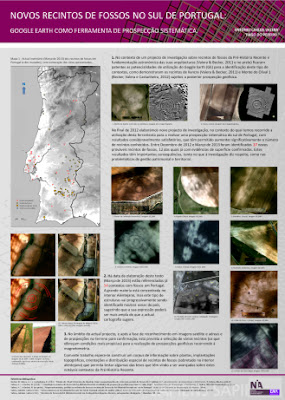
Um doutoramento em curso pretende demonstrar o potencial da detecção remota de recintos de fossos com recurso a imagens multiespectrais e térmicas. Recentemente, Bruno Gambinhas apresentou em poster este seu projecto, o qual, ainda que no início, já obteve bons resultados do lado de lá da fronteira. Espera-se, pois, um incremento do conhecimento dos recintos alentejanos nos próximos tempos.

An ongoing PhD aims to demonstrate the potential of remote sensing of ditched enclosures using multispectral and thermal imaging. Recently, Bruno Gambinhas presented a poster of his project, which, although still in its early stages, has already achieved good results on the other side of the border. It is therefore expected that knowledge of Alentejo ditched enclosures will increase in the near future.


Friday, December 4, 2015

0321 – Timings of discover. Do they really matter?


The real nature and dimension of Perdigões was discovered in 1996 after a field of olive trees was converted, by the removal of the trees and a deep ploughing, into a field prepared to receive a vineyard. It was then that thousands of archaeological materials came to the surface and several ditches became visible in the ground and especially in the aerial image taken in that year.

At the time, the Portuguese archaeology was just awaking to the phenomena of ditched enclosures, and looking for them was not a practice. Portuguese scholars never really questioned the oddness of Santa Vitória (de first ditched enclosure being excavated in Portugal) and the oddness of the apparent isolation of Iberia from a relevant European phenomena in Recent Prehistory. Only in the last decade that work has been done, with success I might had (and this blog shows it), using the available aerial and satellite images, namely the ones provided by Google Earth.

Google Earth was not available in the nineties, but other aerial images were. And if there was the expectation for this kind of contexts to appear and the practice of looking for them, Perdigões could have been identified before the site was ploughed, for the outside double ditches were quite visible in an image of 1995 (just in the lower area of the image).


The question is: could have this prevented the ploughing?

It probably wouldn’t. It was in 1997 that the Portuguese Institute of Archaeology (IPA) was created, and only then preventive archaeology really developed. But those times were already of higher awareness for archaeology, due to the Côa case. And that made possible the archaeological work that would show the importance of the site and that would start the trajectory of research that is well known for Perdigões.

But since then we would expect that new discoveries would be protected. Well that is not true. Several enclosures that were recently discovered have been affected by intensive agriculture, namely to plant olive trees and vineyards. Some were discovered to late (like this one) while others were recently affected, even after geophysics had been done with very good results that show the presence of an important archaeological site, as it happened with Montoito.

Alentejo is being submitted to a significant change in agriculture. This change is threatening this fantastic heritage of prehistoric ditched enclosures that we are recently aware of. I elected them as one of my main topics of research and I am doing what I can to bring them to the public knowledge and to alert to these problems. It is important that the public institutions responsible for the Portuguese heritage be also aware of this situation and act accordingly.

Wednesday, May 20, 2015

0299 – A new one (of two)


Today, just a few hours before giving a talk about large ditched enclosures in the Lisbon Society of Geography through a collaboration with Era Arqueologia, I identified two new ones in Alentejo while I was locating, in Google Earth, some emergency excavations done in the context of Edia water supply network.

Here is the bigger one. Not one of the largest (it has about 2,2 ha “only”), but quite near to two larger ones (Salvada and Monte das Cabeceiras) that are already too close to each other.

It looks that there is an internal enclosure with a wavy ditch and a double ditch defining an outside enclosure.

I do not know yet the chronologies of these new site, but the density of ditched enclosures around Beja is amazing.

Wednesday, March 11, 2015

0285 - They keep appearing

Some possible new ditched enclosures were identified in Google Earth.

Sub-circular enclosure in Mourão municipality.

One seems to correspond to a single ditch enclosure, while the other site seems to present a larger circular enclosure and nearby two more, of smaller size: one possible sinuous ditch slightly overlapped by a small double ditched circular enclosure in the west side.

Possible assemblage of enclosures at north of Beja.

This situation of proximity of different enclosures is becoming more frequent, and a paper that documents that situation through excavation is just coming out (Valera, Ramos e Castanheira, 2015). Situations that probably document the periodic use of a same area with a successive abandonment and construction of enclosures.

References

Valera, A.C., Ramos, R. e Castanehira, P. (2015), “Os recintos de fossos de Coelheira 2 (Santa Vitória, Beja)”, Apontamentos de Arqueologia e Património, 10, Lisboa, NIA-ERA, p.33-45.

Tuesday, August 12, 2014

0258 – Return with a new one


I’ve been away from this space for several weeks, mainly because I was in excavations in the ditched enclosure of Perdigões. It is now time to come back and recover the usual posting regularity. And nothing better than coming back with a new discovery in Alentejo: another small circular ditched enclosure in Beja district. Courtesy of Tiago do Pereiro.

Thursday, April 24, 2014

0248 - Just found another


It is a small one, near the border in Portalegre district. It has at least three concentric ditches (possibly four) and about 90m diameter for the outer one.

Monday, April 21, 2014

0247 – An ex-new one

This is a new ditched enclosure recently found in Google (by Tiago do Pereiro) in North Alentejo. In my inventory is number 63 in Portugal. It is quite visible in the image of 2006.


In March 2009 the situation was as follow: a change in the agricultural use of the soil was threatening the enclosure.


And just a few months later, in August 2009, the site was affected by the new plantation. It looks like a vineyard and, if so, the impact was strong, for ploughing for vineyards is deep.


This happens because, in Portugal, impact assessment legislation is not applied to large agricultural programs with deep impact in the soil. Now, the site is inaccessible, even for geophysics, and probably suffered a strong destructive effect. And it seems relatively small (70m diameter), so if it was discovered in time through an archaeological preliminary prospection, it could became a protected area without a significant economic impact for the agricultural project, and could be used for other cultures with less effects in the ground.

Why are this things still happening? By many reasons. But the surprising expression of ditched enclosures contexts in South Portugal cannot be one of them. Not anymore.

Friday, February 28, 2014

0241 – Looking a little further

Click to enlarge

Satellite images in Google or other areal images are good to detect some ditched enclosures. But to get more and better information, geophysics is needed. However, we can only do a little bit more with those previous images. Some color treatment and enhancement can provide some new surprises, even if they are not to clear.  

At this new site, apart from the three ring ditches and a smaller circular enclosure inside, we can now see what might be some entrance structures in the east side (arrow). But even more interesting, a previous circular enclosure seems to be there.


This site needs geophysics.

Tuesday, February 25, 2014

0240 - Recently discovered...

... through google in Beja district (again).


Monday, November 18, 2013

0221 - Poster on ditched enclosures found in Google Earth

Presented to the I Congress of the Portuguese Association of Archaeologists...


See here

Saturday, March 9, 2013

0166 - Confirming a new one


Confirmation of ditched enclosures aerial images has several stages. After identification on an image, it is important to go to the place and see if there is prehistoric material on the surface. If so, the finding is reinforced, but some still need deeper confirmation and definition, that can be obtain by geophysical survey or traditional excavation survey. At this stage of our project we are just performing the two first steps (occasionally, as in Monte das Cabeceiras 2, mitigation work allowed confirmation through diggings).

Nevertheless, in the first step (identification by aerial image) there is a way of controlling the quality of the information: if the same signs appear in images from different years, especially if they have several years of interval, than the probability of a correct identification increases significantly, as it happens in this new case, in Portalegre district. We still don't have surface confirmation for this one, but it looks like a double ditched enclosure (like the outside ditches of Perdigões, or Monte das Cabeceiras or Salvada, but not with the internal sinuous ditch of the later two). It will havemore than 200m of maximum extent, which will put it in the middle size group of enclosures. The left image is from 1995 and the right one is from 2006. Eleven years in between clearly reinforce the interpretation.


Friday, March 8, 2013

0164 – Destruction of ditched enclosures


This is a major problem for ditched enclosures in Alentejo region. In the last few years agricultural fields are being reconverted and olive trees and vineyards are being planted in extensive areas. This is done without any previous Archaeological survey and the result is that a lot of archaeological sites are affected, destroyed or become inaccessible to research (for instance, for geophysical survey).

This is happening with some ditched enclosures, and our “google prospection” is documenting it, for some sites identified in images from 2003 or 2006 are now invisible or almost.

It was this that happened to Perdigões enclosure 16 years ago. There, though, it was possible to interrupt the process after the plowing and assume the area as an archaeological reserve. But recently, several others do not have the same fortune.


 Examples of identifiable enclosures in recent aerial images (left) and their actual situation (right).

Tuesday, January 1, 2013

0139 – 2013... a happy year for ditched enclosures archaeology?

Well, I certainly hope so. And, as a way to wish everybody that follows this blog a good year full of achievements, I present an image of our expectations for the beginning of this new year: two pictures, the first with the number of Neolithic and Chalcolithic ditched enclosures known and confirmed in 2012 for Alentejo’s hinterland; the second with the number of sites identified by me and Tiago do Pereiro in google that wait to be confirmed in the field during 2013 in the same region.  The images speak for themselves.


And here are some images of some of those sites (some others were posted in earlier posts here).


Not everything is clouded in Portugal.