By Margarida Figueiredo
Location: Vidigueira municipality, Beja district, Alentejo,
South Portugal)
(X=39131.115; Y=128230.640;
Z=151.098)
Chronology: Late Neolithic
Bibliographic references: still unpublished
In the context
of rescue archaeology related to the Edia´s water supply infrastructures it was
discovered and surveyed the ditched enclosure of Fareleira 3, implanted in the Southeast edge of a broad plane surrounded
by water, good soils and privileged view.
The
archaeological context included a wide range of negative structures, excavated in
the soft local bed rock consistent with an habitation context: with a great
variety of pits and one shack basis, all with circular shapes, and what it
appears to be a delimitation ditch, or more correctly 4 segments/modules of the
same ditch in clear association with different kinds of post holes.
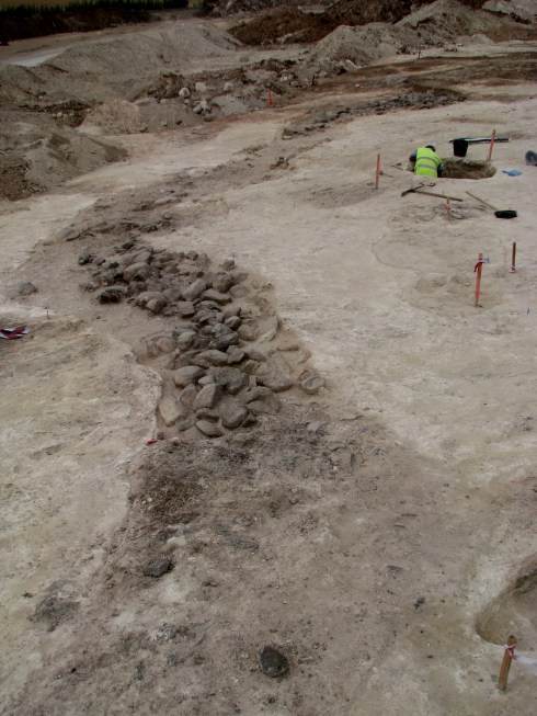
256- general view of the ditches
Spread over a
visible area of around 0,5ha these structures were divided into two different
areas and acted like two different and well assumed spaces: the first one
delimited by the ditch, with a major concentration of pits and post holes. The
second one, with a much more dispersed pattern, and exclusively formed by pits,
concentrated in the opposite limit of the site. The very distinctive process of
the different fillings in these structures amongst the two groups was itself
very meaningful. It showed a much more complex filling, with constant
re-cuttings of the preceding layers and with more ample sequence of deposits,
joined with a generous quantity of material: ceramic, lithic, faunal remains
and large depositions of stones; over the singled filing (very similar to the
geologic cut-off during the opening of the pits), with none or very few elements
allowing for reasonable dating.
The profusion
of pottery, especially in the interior of those ditches, is essential when
framing this enclosure in the last quarter of the IV millennium, with a
consistency inherent to all layers. This means that in spite of the different phases
of occupation and final abandon, the time line was very short, with no serious
alterations in what we may call the way of living.
Although
no general plan is available we have almost 40 meter of a circular alignment of
4 short ditches merged with 4 post-holes. These ditches are different in depth,
filling and width. The shorter ones (South limit) – [2513], [2402] e [2404] – presuppose
a “boomerang shape plan” with similar sizes (5.50m long per 1.80m wide). While
the isolated structure on the North limit – [2304] – longer and thinner than
the rest (12.5m long per 1m wide) is more sinuously waved. All of them are “U”
shaped structures with straight walls and depths that go from 0.46 to 1.30 meters.
218- Surveys 21, 23, 24 & 25
It
looks like being the work of two different contractors: the first three interrelated
segments on the south end represent a one stage building process with the
excavation of the two contiguous segments overlapped by a third one working has
a clinch between them, assisted by a multiple post-hole structure. The isolated
ditch has nothing to do with this complex building system, but maybe that is
because it corresponds to an in-between gate module.
210- [2508] [2509] [2513]
192- [2402] [2404] [2406]
There
were diagnosed two empty spaces in this line of ditches, which can be looked at
from two perspectives: either they represent entrances or they indicate an
unfinished work. In spite of our belief in a building staged process, it is
more likely that those ditches represent deliberate gates. Both are located in
the eastern side of the enclosure, a common feature to most of the enclosures
spread all over the Alentejo. This fact has been studied and interpreted as a cosmological
constraint, the symbolic facing to the winter solstice (Valera e Beckett,
2011).
262 - View of the works.
All
these descriptions look familiar, but what do they actually tell us when it
comes to their functionality and meanings? We hope that with a thorough study
of the materials and a broader view of the site we can get some more answers
and associate them with some other similar negative structures.
Margarida Figueiredo