Friday, September 28, 2012

0112 - Interpreting geophysics


Here is the image of the magnetogram of the ditched and palisade enclosure of Monte do Olival 1 with Helmut Becker’s interpretation of the negative structures present at the site. This interpretation will be published next month in the electronic journal Apontamentos de Arqueologia e Património (a free download journal).

One of the things we learn with Helmut is that having a magnetogram is not enough. We also need good interpretation, based on the knowledge of geophysics, but also of the type of contexts we are dealing with.

Monday, September 24, 2012

0111 - Re-excavating ditches


Sections of the outside ditch at Bela Vista 5:a previous layer was excavated in the centre and after refilled with other deposits.


This is, in a certain way, another version of overlapped ditches problem. In fact, it is frequent to record evidences of ditches that were reopened, by the re-excavation of part of its previous fillings. It is important to notice that only when the reopening is partial is it
detectable by archaeology. The total remove of previous filling deposits leaves no evidence, and if they occurred, then these activities would have been even more common.
This creates problems to ditch dating, because there might be a significant time between the initial excavation of a ditch and its last filling sequence. Only with several sections and good dating sequences we can evaluate these problems.

But another problem is why they reopened some ditches? And why frequently just a central part of the ditch, leaving a ditch with “walls of sediment”? Is it because they want to rapidly fill it again with new deposits and materials? They must have done so, otherwise those “walls of sediment” would have been eroded (and we can clearly see them in some sections, like the one presented here).

This kind of stratigraphic sequences points to human intentionality in the formation of the deposits inside ditches, not just because of the materials or the structured organization they might present. The structure of the deposits itself may be an argument to that intentionality.

Thursday, September 20, 2012

0110 - Overlapping ditches

This is an important issue for ditched enclosures understanding that hasn’t been researched as it deserves in Iberia. Here is a situation from Perdigões that we just started to approach.


 In sector P we open an area to research the overlapping of ditches 7 and 8. The first observation is that, contrary to what we assumed by the geophysics magnetogram, ditch 8 is older than ditch 7. In fact, it is ditch 7 that cuts ditch 8, and partially “walks over it” in the excavated section.


And that is really odd. Why open a ditch (which implies a lot of work and effort) in the bed rock, and then cut just partially, in small distances, a previous ditch? Why not use more of that previous ditch?  Or, why not fully avoid that previous ditch?

It seems that they just wanted to cut a new ditch, with a wavy plan, with no regard to previous ditch 8. But, if we look to the magnetogram, ditch 8 is a concentric mach to previous ditch 6. And why the ditch has part f its trajectory inside ditch 7, and then sudden  get outside, and then curved to be over it, just to get in again?

The conclusion is that no easy modern rational explanation can deal with these strange practices of opening ditches at Perdigões. We must keep our minds opened in the presence of these enclosed spaces.  The previous seems to condition the posterior, but in very complex ways not easy to explain.

Sunday, September 16, 2012

0109 - Geology and enclosures

In the paper quoted in the last post I draw attention to the relation of the decorated Bell Beaker pottery contexts and the geology of South Portugal. At the presentation in the 2005 meeting I showed the following map that clearly shows the concentration of the sites within well defined geological borders.


The middle Guadiana basin, with its geological diversity and good soils and plains, and the poor littoral sandy platform and the schist with wavy topography at the south, making the north limit of the mountains that separate Alentejo from Algarve littoral platform.

Well this same situation can be observed in the enclosures distribution as we know it today (or for the megalithic or hypogeal graves). The line in the map of enclosures marks the same geological limit of the first map. And it speaks for itself: there is a strong connection between the structural geology of south Portugal and the structural aspects of its human occupation.


Friday, September 14, 2012

0108 - Ditches and Bell Beakers


Bell Beakers are not common in Portuguese ditched enclosures. Well, in the small ones. There, they are virtually unknown. Even in those built in bell beaker times.

But at the enclosures that grew bigger, to became large ones, like Perdigões and Porto Torrão, beakers are present and they can be very well represented (as it happens in Porto Torrão).

But that is not it. A pattern emerged in the last years. In small sites, sometimes reoccupations of walled enclosures (but never ditched ones), we tend to have beakers of a mono style (maritime, or incise, or combed geometric). But the large ditched enclosures are the only ones where we have all these styles together.

A paper of mine has recently been published on this issue here.

Notice that in the maps, Perdigões is told to only have maritime and incised beakers. Well, this summer things changed, and combed geometric beakers also are present.

In fact, as Perdigões, Porto Torrão and Bela Vista 5 chronologies show, at beaker times ditches were still being built in west Iberia. Sometimes enlarging previous enclosures (like in Perdigões), sometimes creating original enclosures (like at Bela Vista 5).

But only in the big ones we have the presence of the three main styles. Another sign of the social role of these large enclosures.

Wednesday, September 12, 2012

0107 - The small enclosure of Carrascal (Porto Torrão)


It was a project developed by Era Arqueologia, and the geophysics was, of course, done by Helmut Becker with the results he usually provides.

Just 800 meters way from Porto Torrão traditional limits, and associated to a large area of necropolis, here is a small and perfectly circular ditched enclosure, with just 20m diameter.

A gate is visible at NW, possible orientated to sunset summer solstice.

At Porto Torrão things are much more complex than everybody expected and, I would argue, still expect.

Saturday, September 8, 2012

0106 - “Idols” in ditches

Is the second situation in Perdigões, separated from the first one by more the 500 hundred years: the depositions of idols in the bottom of ditches.

The first situation was detected in ditch 1 (Mata et al., 2011), dated from de second half of the 3rd millennium BC. A schist idol, with lateral cuts, was found deposited just at the bottom of the ditch, associated to a complete pot and some faunal remains.


Idol in Ditch 1 (After Mata et al. 2011)
 
The second situation was recorded this year, in ditch 12, dated from Late Neolithic. An assemblage of 5 Almeriense Idols was recovered at the bottom of the ditch. I am just finishing a paper on this context that will be published next October.

 
Idols in ditch 12.

These situations, although apart in time, document a same general fact: the filling of the ditches was, frequently, the result of intentional human action and they might document a ritualization of the beginning of those processes. Unless we admit they were just lost by someone passing by.

More and more evidences are appearing every year to create problems to the “erosion” and “garbage” explanations of ditch fillings and to support other interpretations that take into account human activity and intentionality.  

References:

Mata, E., Fernández, J. e Caro, J.L. (2011), "Figurinha en xisto procedente del relleno del foso 1 del complexo arqueológico dos Perdigões (Reguengos de Monsaraz", Apontamentos de Arqueologia e Património, 7, NIA-ERA, p.19-21.

Tuesday, September 4, 2012

0105 - Bela Vista 5


Location: Beja municipality, Beja district, Alentejo, South Portugal)
Chronology: Late Chalcolitic /Early Bronze Age
Bibliographic references: unpublished.

The archaeological materials, namely the pottery, already suggested that this enclosure would be a later one in the context of Iberian ditched enclosures (see post 96).

Radiocabon recently confirmed that idea, by putting the ditches in the last three hundred years of the 3rd millennium BC.

But there are earlier pits and pits later than this time span, so the enclosure was added to an already existing site and pits continued to be built after the ditches were filled.

And not far (less than a kilometre to East and to West), necropolis of hipogea from Late Neolithic and Bronze Age were detected and excavated.

Friday, July 13, 2012

0104 - Enclosures and abandonment (1)

The walled enclosure of Monte da Tumba (Torrão, Alentejo) is a good example of an intermediate abandonment in a site that originally (Silva & Soares, 1987) was considered to have a continuous sequence of occupation. 


“The potent stratigraphic sequence of Phase I is interrupted by also potent wall ruins. Over these ruins a new occupation phase took place and new constructions are built. In this phase, a house seems to have been burned and the roof has fallen, preserving a material assemblage in good state. New ruins are then identified and a new (3rd) phase is defined, also with new constructions, like a central tower. According to the excavators, this sequence of continuous occupation is of 500 years.”

“In this discourse, no temporary abandonments were considered. In reality, it is not probable that two moments where powerful wall ruins are formed over which new construction are built and substantial changes in material culture can be observed (like the appearance of copper metallurgy in Phase 2 or the bell beakers in phase 3) didn’t implied interruptions in the occupation of the site. Ruins and generalized destructions as described do not happen in a day (unless by catastrophe) fallowed by a new occupation next day, with new constructions, new technologies and new artefacts previously inexistent. And we must remember we are talking about 500 years.”
(taken from Valera, 2003)

In fact, this sequence clearly suggests the existence of periods of abandonment in the sequence of occupation of the site. Determine the reasons of those abandonments, their dynamics and duration (all people left at the same time? They intend to come back? Were the same, their descendents or others that reoccupied the site? Etc.), and the reasons of reoccupation are central to understand the role of these sites in local and regional settlement networks and their historical circumstances throughout time. Abandonments are as important as occupations, just like what is missing is as important as what is present. 

References:
Silva, C.T & Soares, J. (1987), “O povoado fortificado calcolítico do Monte da Tumba I – escavações de 1982-86 (resultados preliminares)”, Setúbal Arqueológica, VIII, Setúbal, p.29-79.
Valera, António Carlos (2003), “Mobilidade estratégica e prolongamento simbólico: problemáticas do abandono no povoamento calcolítico do Ocidente Peninsular”, Era Arqueologia, 5, Lisboa, p.126-149. (http://www.academia.edu/attachments/2325706/download_file)

Friday, July 6, 2012

0103 - The importance of good geophysics

The importance of good geophysics is evident. It can provide a global image of a site (that we can only have by traditional archaeological excavation after at least some decades) allowing the development of the scientific inquiry and research, it is not intrusive, so it doesn’t rise the problems that an excavation does, and provides a powerful planning tool (in research or impact assessment contexts).

At Perdigões, the geophysics done by Helmut Becker (Márquez-Romero et al. 2011; Valera et al., in press) is important, not just for the general interpretation of the site, but because it allows the contextualization of the excavated areas in a broader picture. Now we know exactly where we are in the site. But also important, we can plan where we want to be.

And in this year campaign, this is one of the places we want to be: the area inside Late Neolithic Ditch 6, where the geophysics showed two tiny lines that might correspond to palisades.

Fragment of the geophysics of Perdigões with the location of the area to survey

Well, we prepared the excavation by removing the ploughed upper level, and there it was: Ditch 6 and inside two smaller parallel ditches corresponding to the geophysical image (with an extra: a small pit between Ditch 6 and the first inside line). The goals, now, are characterize these structures, try to determine their functionality and date them.

Survey area, confirming the presence of the structures.

References:
Márquez, J.E.; Valera, A.C.; Becker, H.; Jiménez, V. & Suárez, J. (2011), “El Complexo Arqueológico dos Perdigões (Reguengos de Monsaraz, Portugal). Prospecciones Geofísicas – Campaña 2008-09.” Trabajos de Prehistoria, Madrid.

Valera, A.C, Márquez, J.E., Becker, H., Jiménez, V. & Suárez, J. (in press B), “O Complexo Arqueológico dos Perdigões: nova imagem e novos problemas proporcionados pela prospecção geofísica” Actas do 8º Encontro de Arqueologia do Algarve, (2010), Silves.

Wednesday, July 4, 2012

0102 - List of Portuguese enclosures updated

Click to enlarge

Walled enclosures (red squares)
Ditched enclosures (yellow circles)
Walled and ditches enclosures (blue stars)

It will stay available in the page dedicated to maps.

Sunday, July 1, 2012

0101 - Fonte Quente walled enclosure


Image of the wall structures on Fonte Quente (taken from Batata & Borges, 2011)


Location: Tomar municipality, Santarém district, Central Portugal)
Chronology: Chalcolithic
Bibliographic references: Oosterbeek, 1994; Batata & Borges, 2011.

Known since the early times of the XX century, and with several interventions along that century, the Fonte Seca site was recently submitted to a large area excavation, due to the construction of a highway (Batata & Borges, 2011). This last intervention revealed a large walled enclosure. According to the excavators, it is now one of the biggest of Central Portugal, with an estimated area around 20ha.

Three walls were detected, some with semi circular bastions. Metal artefacts and evidences of copper metallurgy were also recorded as well as beaker pottery and schist plaques with geometric decoration (typical of Alentejo region, but also present in the Tejo valley).

In an earlier survey (Oosterbeek, 1994) one radiocarbon date was associated to one of the walls: 3790+/-120BP. Calibrated at 2σ, and due to its large standard deviation, this date presents a huge interval between 2600 – 1850 cal BC, but that goes well with the later materials, like the beaker pottery.  

Bibliographic References

OOSTERBEEK, Luiz (1994) – Echoes from the east: the Western Network – North Ribatejo (Portugal): an insight to unequal and combined development, 7000 – 2000 B.C., University College London, Institute of Archaeology.

BATATA, C. & BORGES, N. (2011), “A importância da Fonte Quente enquanto “Lugar Central” no contexto do povoamento Pré-Histórico do Alto Ribatejo, durante a Pré-História Recente”, Resumo dos trabalhos de escavação arqueológica realizados no decorrer da empreitada do Sublanço do IC9 – Nó de Carregueiros / Tomar, E.P. Estradas de Portugal.

Friday, June 22, 2012

0100 - Going public

I talked about this before: the archaeology of prehistoric enclosures (as all archaeology actually) needs to go public. In fact, its relevance (and the relevance of its professionals) critically depends in the capacity of produce some valued social return, and there are some interesting projects all over Europe working this way.

In Portugal, we are just beginning, and Perdigões is a leading project on that matter, assuming that research has its own funding future and social justification in becoming relevant to the general public. But we are also aware that its relevance depends back in regular research of quality.

So, at Perdigões there is a path that is being walked with conviction in social responsibility. And that has been noticed here and there.

Even Google caught us excavating last year (2011). It was the first week of field work. And we will be there again this year. Next week we will be preparing the excavation that will start at July 16th. You can fallow it then in its own blog (see the side bar).


Monday, June 18, 2012

0099 - Ditched enclosures in the Portuguese north hinterland


Ditched enclosures in central/north Portugal (Yellow circles). Santa Bárbara is number 30.

The actual distribution of ditched enclosures in Portugal shows a clear concentration in Alentejo region, in the Guadiana and Sado basins. But some enclosures with ditches also started to appear in the north part of the country. First in the littoral. But in the last years they were detected also in the hinterland, in Beira Interior.

Is the case of the ditched enclosure of Santa Bárbara, Sabugal (Peresterlo & Osório, 2005). Unfortunately there is not much information published about the site and its negative structures. Through some newspapers articles we know that there are pits and a ditch (25 meters long and 3 meters wide), apparently dating from the Chalcolithic.

The site is very near the Spanish border and that region of Portugal is part of the western traditional pathway between the two Iberian central Mesetas and a natural extension of the central territories, both north and south of the Central Mountain System. Well, in both areas, the Madrid region and the Douro valley, the last decades have revealed a significant density of ditched enclosures. Besides, the Beira Interior region is also well connected to the South, being part of that north-south route that links three mains river valleys: the Douro, the Tagus and the Guadiana.

It is a linking region, well marked in several historical periods (such as in the Bronze Age through stelae distribution), connected to areas where ditched enclosures are very well represented. So, it was just a matter of time before they started to appear here too. And more are expected for the near future.  

Thursday, June 14, 2012

0098 - Dating ditch fillings


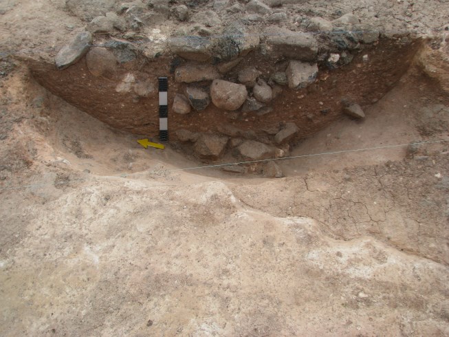
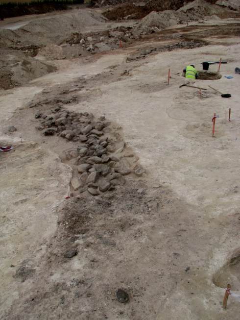
Dates from ditches 3 and 4 from Perdigões. They are Chalcolithic ditches, dated from the 2nd quarter and middle 3th millennium BC. But in a top layer of ditch 4 we got a Late Neolithic date (a ditch that has to middle 3rd millennium dates for bottom deposits). A typical situation of incorporation of earlier material. In fact, just 3 meters away there was a Late Neolithic pit burial that was disturbed in Chalcolithic times. Taken from Valera & Silva, 2011.


Dating the fillings of ditches and interpret the results is a tricky issue.

First, we must be aware that we never date the opening of a ditch, only the beginning of its filling. And we do not know the time between the opening and the beginning of the last filling process of the ditch (I say last because we must considerer the possibilities of re-openings).

Second, what is integrated in the ditch filling may be older than the filling process or even older than the excavation of the ditch. In fact, especially in sites with long living periods (like Perdigões, for instance), where earlier materials can be about or the excavation activity is so intense that earlier deposits are constantly being remobilized, it is natural that some of the material that integrates a filling deposit inside a ditch is actually from earlier occupations. By dating this material we will not date what we intent to. We will be dating earlier material that has nothing to do with the time the ditch building or its filling moments. That is why sometimes we have earlier dates in top deposits and later ones in the bottom deposits.

So, how can we avoid these problems?

Dating ditch fillings implies dating series of samples, where outliers can be detected. It is not just the need of dating the sequence of deposits to determine the filling rhythm (which is, of course, important). Even if there are just one or two deposits, we must have more than just one date, precisely because of the problems raised by the typical dynamics and activities that take place in this kind of sites.

It is more expensive, I know. But one date in a ditch, except if you have a well defined and closed context (like a burial, for instance), is far from enough. And every date or series of dates need a serious critique, regarding the dating procedures, dated material, relation to context, nature of the context formation, post depositional events, and so on. Or we will just adding smoke to an already foggy area.

Bibliographic References:
Valera, A. C. & Silva, A. M. (2011), “Datações de radiocarbono para os Perdigões (1): contextos com restos humanos nos Sectores I e Q”, Apontamentos de Arqueologia e Património, 7, Lisboa, NIA-ERA, p.7-14.

Monday, June 11, 2012

0097 - How did they do it?


They did choose adequate bedrocks. There is a clear relation between Portuguese ditched enclosures and geology that enables an easier excavation. But making it easier doesn’t mean it was easy.

In fact, to excavate the ditches, that in South Portugal started at least in Late Neolithic (second half of the 4th millennium), they must have used the technology developed since earlier times: the technology developed in mining for flint or for minerals, like variscite.

I have already drawn the attention for the fact that there are several evidences of “transference of technology” in Prehistory, from some areas to others; from some kind of architectures to others. For instance, the building of the access corridor between walls to the inside enclosure of Castro de Santiago is clearly an application of megalithic building procedures.

So, to study the technologies adopted to open ditches it is in mining tools and in mining techniques that we might find a window. There is a clear interesting relation that can be established between the researches of these two Neolithic practices.

And the same can be argued about the hypogeal building tradition. There is knowledge and an assemblage of techniques and tools that must have had a transversal use in different building activities. Underground techniques of excavation are certainly earlier than ditched enclosures in western Iberia. They might have provided the means to the architectural materialization of some new ideas. Just like the megalithic “engineering” was certainly helpful for walled enclosures.

So, looking into mines, and mining material, might be useful when we study ditched enclosures.

Wednesday, June 6, 2012

0096 - The sunset of ditched enclosures?


Small inside enclosure with a burial pit.


When did the Neolithic and Chalcolithic type of ditched enclosures stop being built? Well, as the question suggests, it would have been at the end of the Chalcolithic, of course. In fact, at the present moment, no ditched enclosures like those are known to have been built in the second millennium BC. I recently have used this apparent situation to argue that the Neolithic and Chalcolithic ditched enclosures were related to a specific ideology (or cosmogony) and that they stopped being built in the beginning of the second millennium precisely because that cosmogony was structurally changing at the end of the third millennia (Valera, in press).

Well, the enclosure in excavation by ERA at the moment seams to reveal a relative late chronology, although every elements of the architecture also seems to be rooted in the Neolithic tradition. It is soon to be conclusive. But the pottery from the ditches suggests a late chronology in the third millennium and there are pits with pottery that clearly indicate the first half of the second millennium (Bronze Age).

The image, at the moment, is that the enclosures were built in a late Chalcolithic and that pits were still being excavated in the early Bronze Age. But the relations are still to be established. In fact, the inside ditch, the one that slides deeper from the gate to de back, is very small (just 8 m diameter inside) and has only one pit inside. Well that pit has an individual burial with three complete undecorated vessels and a Palmela point, indicating a moment of transition to Bronze Age. Is it a latter pit? Or this small enclosure was built to enclose that pit?


Detail of the burial excavation in a earlier stage. We can see the leg and the skull (and a stone over the neck).

It is soon to decide. But what this data is suggesting is that some of this Neolithic rooted architecture and practices might have reached the beginning of Bronze Age. In a way not yet recorded.

That does not question yet the idea that those architectures are essentially related to a Neolithic cosmogony. Structural transitions are just like that, presenting punctual and exceptional late extensions. So let’s see what the absolute chronology says.

One thing is already certain: this site is important to the problematics regarding Portuguese ditched enclosures.     

Refrences:
Valera, A.C (in press) “Mind the gap: Neolithic and Chalcolithic enclosures of South Portugal” (A. Gibson & J. Leary, eds), ENCLOSING THE NEOLITHIC: RECENT STUDIES IN BRITAIN AND EUROPE, BAR.

Thursday, May 31, 2012

0095 – Modular architectures

This is an interesting perspective into ditched enclosures building procedures: the possibility that a ditch is not done in a row, but is a result of several modules, parts, that are added. The enclosure is a result of a process. The result is a sequence of overlapped (or almost overlapped) sections of short ditches, frequently with different dimensions.

I argue about this possibility recently, in two papers (Valera & Becker, 2011; Valera, in press). My first contact with the idea was in a paper on Herhxeim enclosures (a Neolithic LBK site), where human bones were scattered inside overlapping sections of ditches that, at the end, defined an enclosure. Then I read a short sentence in a blog from Manuel Calado and the excavations he did in Salgada (Borba, Alentejo), where he spoke of a similar situation (only with no human bones). I even did a post on that issue (see here).
Then I recall the thesis of Pedro Diaz del Rio (2008) about the building process of some walled enclosures: the possibility that walls in sites such as Los Millares or Castanheiro do Vento might have been built in modules; as independent, but converging, projects develop through time as a metaphor of a trans equalitarian social organization, still far from coercive and well stratified social relations.   

When the geophysical image of Xancra came out of the magical machine of Helmut Becker, it became clear to me that we might be in presence of a similar situation of a ditch built through the adding of modules. This is quite clear in the outside ditch of Xancra, as I point it out in the paper (Valera & Becker, 2011).


The highlights show areas where parts of the ditch seam to “join” or “overlap”.

Well, the enclosure under excavation by Era in Alentejo is confirming this situation. In the external ditch we are documenting sections, with different depths and widths, that are overlapping showing, with no doubt,  that the final enclosure is the result of a sequence of additions of ditch sections with different dimensions and made in different moments in time. The building of this outside enclosure was a long process. It was not made at once. And, naturally, it was not for defence or drainage.


Here is a gate. In both sides there is a section of the ditch that is not very deep. Then, in both sides, two new sections were made, more deep and  large, cutting the previous sections. It is clear the semi circular joining of the different sections.


Here is another overlap: the left part of the ditched, already filled, was excavated in a slide way and the new section filled with a different sequence of depositions.


Here we can see the top of the sinuous path of the outside ditch. It is quite clear that there is a part with top stones, then a section almost without stones, and then again a new section with stones (that ends at the cut present in the previous image). Even at the top filling this sectioning of the ditch is visible.

I wonder when the traditional discourse, that sees fortified settlements in all these sites, will get in time with the actual empirical evidence.  

Ah! Yes, I almost forgot: there are funerary contexts inside.

Bibliographic References:
DIÁZ-DEL-RIO, Pedro (2008), “El context social de las agregaciones de población durante el Calcolítico Peninsular”, ERA Arqueologia, 8, Lisboa, Era-Arqueologia / Colibri, p.128-137.
VALERA, António Carlos (in press), “Fossos sinuosos na Pré-História Recente do Sul de Portugal: ensaio de análise crítica”, Actas do V Encontro de Arqueologia do SW Peninsular.
VALERA, António Carlos & BECKER, Helmut (2011), “Cosmologia e recintos de fossos da Pré-História Recente: resultados da prospecção geofísica em Xancra (Cuba, Beja)”, Apontamentos de Arqueologia e Património, 7, Lisboa, NIA-ERA, p.23-32.

Wednesday, May 23, 2012

0094 – The irregularity of ditches.


The inner ditch of the enclosure in excavation process: 1,5m deep in first plan survey (back of the dich); 1,3m deep in the next one; 0,8 at the gate. Notice the presence of a layer of geological material at middle depth.

The irregularity of ditches, not in plan, but in depth, is another issue that is very important to question functionality and meaning.

It is expectable that a ditch to accomplish the function of defence or infrastructure of a palisade presents a general regularity in terms of depth. The problem is that for almost all Portuguese ditched enclosures only small parts of ditches were surveyed. But recently to exceptions to this “rule” allow treating this problem.

At Senhora da Alegria, a small enclosure (about 10 meters diameter) at the top of the site presented a circular plan with one gate and only a pit inside. The pit had inside large fragments of burned wood and the ditch revealed a interesting depth profile: it grows deeper from the back towards the gate, with a significant slide percentage.

At the enclosure in process of excavation in Alentejo the inside ditch presents a similar size and also just one gate. But the depth of the ditch reveals the opposite behaviour: it grows deeper from the gate sides to the back: 0.8 / 0.4 at both sides of the gate and 1,5 at the back of the circle. So it presents also a significant slide. Inside, also just one pit, still in excavation (sealed with stones and with complete pots underneath).

What the strange behaviour of the depth of these ditches suggests is that they cannot be associated to any kind of palisade or regular barrier: were they built to be walked inside, from the surface to a deeper area? It has something to do with water circulation and accumulation in a specific area of the ditch? I recall that at least one of the ditches of the enclosure of Águas Frias the structure also ended in a sort of ramp. Let us see what this new enclosure has to reveal in the next days. For the moment the fillings of the ditches are as heterogeneous as their depths.


The back of the ditch: note the absence of geological material layer just one meter away from the other profile.